


Water Safety
Pillings Pond Foundation, Inc. — 501(c)(3) — Lynnfield, Massachusetts
Know the Pond Before You Launch
Pillings Pond looks wide open from shore, but much of it is far shallower than it appears. If you are new to the pond, whether in a motorboat, pontoon, jet ski, kayak, or paddleboard, please take two minutes with this page before you head out.
Hazards and Depths Map
Known hazards and approximate depths as of 2026. Tap the map to open it full size.
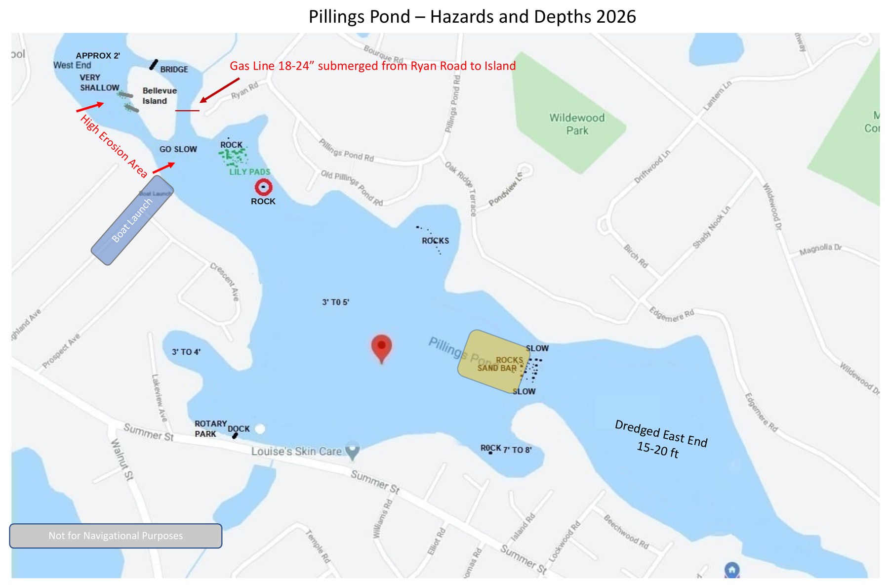
Map for general awareness only. Not for navigational purposes. Depths are approximate.
Why the Pond Is Tricky
Pillings Pond is man-made. According to Town records, it was created sometime between 1831 and 1846, when Bates Brook was dammed to power a water mill. The pond flooded low-lying marshland, and old rock walls remain buried on the bottom, some just below the surface.
In the 1990s the pond was dredged from the east end toward the west. The work was halted for federal permitting reasons when it reached the rock wall near the middle of the pond, and it never resumed. The result is two very different ponds:
Known Hazards
Each of these is shown on the map above.
The rock wall and sandbar
This is the most serious hazard on the pond. Where the dredging stopped, a dangerously shallow sandbar and a partly exposed rock wall remain, and the depth changes abruptly. Do not cut across the middle. You can cross safely at either end of the sandbar by staying about 15 to 20 feet off the shoreline, at idle speed.
Mid-pondThe West End and Bellevue Island
Roughly 2 feet deep and very shallow throughout. The shoreline here is also eroding, so please go slow and leave no wake.
Northwest cornerSubmerged gas line
A gas line runs from Ryan Road to Bellevue Island only 18 to 24 inches below the surface, in a very shallow area. It is not safe for boats or motors. Keep motorized craft out, and never anchor here.
Ryan Road to Bellevue IslandRocks
Two along the north shore beside the lily pads (one is marked with a red bullseye on the map), more in the north cove off Oak Ridge Terrace, and one in the south cove east of Rotary Park.
North shore and both covesLily pads and weeds
Thick growth in the northwest can foul propellers and jet intakes.
NorthwestBoat launch channel and no-wake buoys
The shoreline near the boat launch is a high erosion zone, and it is the pond's no-wake zone. No-wake buoys, approved by the Town in 2021, mark it. Slow to idle and leave no wake whenever you pass them. The launch channel is also narrow and shallow, so keep to idle speed in and out.
Near the boat launchBefore You Head Out
Town Permits
Two Town of Lynnfield permits apply to Pillings Pond. Both applications are on the Town's Licenses & Permits page.
Boat sticker
The Town of Lynnfield requires a boat sticker for every motor-powered craft on Pillings Pond. Kayaks, canoes, and other craft without a motor do not need one. Stickers are issued at Town Hall. The application is listed on the Town's page as "Motorized Craft License on Pillings Pond."
Town Licenses & Permits →Dock permit
All pond abutters must have a Town permit for their dock. The application is listed on the Town's page as "Application for Dock License." Town rules also limit a dock's size, height, spacing, and lighting. See Chapter 184 below for the details.
Town Licenses & Permits →Lynnfield Town Hall, 55 Summer Street, Lynnfield, MA 01940 | 781-334-9400
Town Rules for Pillings Pond
The Town of Lynnfield regulates activity on the pond under Chapter 184 of the Town Code. The key boating rules:
This is a summary only. The Town Code is the official text, and all Massachusetts boating laws also apply.
More Information
- Chapter 184 Article I – Rules and Regulations for Pillings PondCode of the Town of Lynnfield. The full text of the current pond rules.
- Pillings Pond Dredge Feasibility Analysis – Final Report, February 2024 (TRC)The Town's study of pond depth, sediment, and dredging options.
- Town of Lynnfield – Licenses & PermitsBoat sticker and dock permit applications.
- Town of Lynnfield – Pillings Pond LinksConservation Commission resources for the pond.
What We Are Doing About It
The Pillings Pond Foundation is working with the Town of Lynnfield to properly mark these known hazards and prevent a serious accident. Until markers are in place, please use the map as your guide and share it with anyone you bring out on the water.
This page and map are provided for general awareness only and are not for navigational purposes. Boat operators are responsible for their own safe operation.